
An Anatomy of Ruin: Converting Grief into Knowledge
A Himalayan disaster should force Nepal to redesign how a state understands risk, protects its citizens and learns from catastrophe.

Published on : Sun, 13 Sep, 2026
No ads found for this position
 Jitendra GC
No ads found for this position
There are moments when a nation is confronted not merely with a natural disaster, but with a fundamental question about its institutional capacity. The recent catastrophe in Rasuwa is one of those moments.
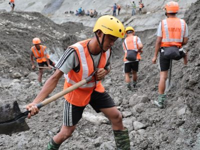
When a sudden, high-altitude cascade of ice and rock tore through the Lhende Khola and surged down the Bhote Koshi–Trishuli river corridor, it did not merely destroy bridges, inundate towns, and sever critical hydropower infrastructure. It exposed the stark limitations of a reactive state. The immediate danger did not end with the first torrent of mud and boulders; secondary risks—unstable landslide dams, impounded water bodies, and shattered communications—paralyzed initial rescue operations and left downstream communities in prolonged panic.
The instinctive response of any government in the wake of such ruin is entirely understandable: rescue the trapped, retrieve the fallen, treat the injured, distribute emergency tents and food, clear debris, and rebuild what was lost. All of that must happen, and it must happen with speed and compassion. But if Nepal’s answer to Rasuwa ends at physical reconstruction, we will have committed a grave strategic error.
Rasuwa must not become merely another entry in the long ledger of post-disaster rehabilitation. It must become Nepal’s national laboratory for disaster resilience—and a global case study for how mountain nations adapt to a warming planet. The central question before Nepal is not simply how quickly we can rebuild a highway or clear a riverbed. It is whether we can emerge from this tragedy with a state apparatus capable of seeing danger before it turns into catastrophe. That distinction is a matter of national survival.
The Hindu Kush Himalaya (HKH)—often termed the Earth’s “Third Pole”—is becoming exponentially more difficult to govern. Stretched across eight nations, this region contains the world’s highest peaks, fragile geological formations, intense seismicity, and a complex hydrological network that feeds ten major river basins. As documented in the landmark Hindu Kush Himalaya Assessment coordinated by the International Centre for Integrated Mountain Development (ICIMOD), this region supports 240 million mountain inhabitants and more than 1.65 billion people downstream. Yet, the IPCC Sixth Assessment Report (AR6) confirms that high-altitude environments are experiencing elevation-dependent warming at rates significantly higher than the global average. Even if global warming is successfully capped at 1.5°C, mountain temperatures across the Himalaya will rise by more than 2°C, melting at least a third of the region’s glaciers by the end of the century and destabilizing permafrost slopes that have remained frozen for millennia.
In this transformed climate reality, scientists observe that even a below-normal monsoon can be punctuated by violent, localized atmospheric bursts. Rain falls on bare ice; permafrost degrades; rock faces collapse; glacial lakes overflow. The old doctrine—wait for the hazard to strike, mobilize the security forces for search and rescue, and then solicit international aid to rebuild—is obsolete.
Nepal must transition from reactive disaster management to predictive disaster intelligence.
The First Reform Is Conceptual
For decades, public policy in developing nations has treated disaster management as a linear sequence of isolated emergencies: a event occurs, emergency workers respond, international agencies provide relief, and contractors begin reconstruction.
A resilient state operates on an entirely different intellectual foundation. It embeds risk assessment into its daily governance, asking six fundamental questions before the mountain moves:
- What combination of hazards can occur?
- Where are those hazards most likely to converge?
- Which populations and assets are exposed?
- How much lead time can our technology generate?
- What pre-arranged protocols will turn warnings into physical evacuations?
- How rapidly can public institutions restore social and economic stability?
The global roadmap for this transition exists. The United Nations Sendai Framework for Disaster Risk Reduction (2015–2030) outlines four clear priorities: understanding disaster risk, strengthening risk governance, investing in resilience, and enhancing disaster preparedness to “Build Back Better.” Furthermore, the UN’s “Early Warnings for All” initiative mandates that every person on Earth be protected by early warning systems.
Nepal does not need another high-level seminar to endorse these principles. It needs to convert them into an unyielding operating system. Rasuwa is where that transformation must begin.
Build a Rasuwa Scientific Assessment
Before heavy machinery accelerates the rebuilding of towns exactly where they stood, Nepal should commission an independent, multidisciplinary scientific investigation into the Rasuwa disaster.
This should not be an administrative panel aimed at distributing political blame or burying uncomfortable facts in bureaucratic prose. It must be an uncompromising exercise in scientific inquiry designed to generate institutional memory.
Glaciologists and cryosphere experts must analyze high-altitude slope stability and glacial retreat along the Tibet-Nepal border. Hydrologists must reconstruct the discharge volume and velocity of the surge wave. Geologists and geomorphologists must evaluate slope failures and riverbed aggradation. Remote-sensing scientists must combine multi-spectral satellite imagery, synthetic aperture radar (SAR), and aerial LiDAR data to map physical changes before and after the event. Engineers must audit the structural failures of bridges, roads, and hydropower dams. Economists must quantify both direct capital destruction and indirect losses to commerce, energy generation, and local livelihoods. Public health specialists must assess waterborne disease vectors and psychological trauma among displaced populations.
Equally important, social scientists must investigate the human dimension: Why did certain communities receive warnings while others did not? Why did some citizens evacuate immediately while others hesitated?
The final output—the Rasuwa Disaster Scientific Assessment—must be published openly, subjected to international peer review, and translated into actionable policy briefs. A country that fails to scientifically analyze its disasters is condemned to pay for them twice.
Create a Digital Twin of Risk
The next step requires a technological leap forward. Nepal should construct a “Digital Twin” of the Trishuli–Bhote Koshi river corridor—a dynamic, high-resolution 3D computational model of the district’s physical, ecological, and built environment.
This digital twin would integrate real-time inputs: satellite radar observations, stream-gauge telemetry, automated weather stations, glacier monitoring data, topography, road networks, bridge spans, hydropower infrastructure, settlement locations, population densities, and critical facilities like hospitals and schools.
Using artificial intelligence and advanced machine learning algorithms, planners can simulate complex future scenarios:
- What happens if a 200-millimeter cloudburst hits an unmonitored sub-basin in Tibet?
- How far downstream will a 10-million-cubic-meter debris flow travel if a landslide blocks the main channel for two hours?
- Which bridges will experience critical scouring, and at what exact river stage will the main highway become impassable?
- If telecommunications towers lose power, which villages will be isolated first?
- Where are the optimal, safe helipads and pre-positioned supply depots located above the maximum flood line?
Such predictive simulation is no longer speculative technology. Across the HKH region, climate institutions are adopting impact-based forecasting—moving beyond predicting what the weather will be to predicting what the weather will do. The objective is not to achieve flawless prophecy, which in dynamic mountain environments is impossible. The objective is to eliminate institutional surprise.
Echoes in the Gorge: The Fifty Meters Between Alert and Escape
(Warning Is Not Enough: People Must Move)
Nepal has earned global recognition for its pioneer work in community-based flood early warning systems along its southern Terai plains. But high-altitude, steep-gradient mountain valleys present a fundamentally different challenge. In narrow gorges, a flash flood or debris flow can travel at speeds exceeding ten meters per second. Lead times are measured in minutes, not hours.
A modern early warning system cannot be evaluated by whether a text message was dispatched from a central bureau in Kathmandu. It must be evaluated by a rigorous four-part test:
- Was the warning delivered instantaneously to the person at risk?
- Was the message clear, authoritative, and actionable?
- Were marked, safe evacuation routes accessible?
- Did the vulnerable individual reach secure shelter before the hazard arrived?
This requires an architecture designed backward from the citizen. The critical question must always be: “What does a family living in a remote hamlet at the bottom of this valley need to know, when do they need to know it, and where should they run?”
The information pipeline must seamlessly link multi-spectral satellites and high-altitude sensors to scientific hubs, scientists to national emergency operations centers, national centers to municipal ward offices, municipal leaders to local security detachments, and automated sirens directly to every mobile phone in the danger zone. If a sensor detects a sudden drop in river flow—a classic signature of an upstream landslide damming the river—automated alerts must trigger local sirens and cut power grid operations without waiting for manual human authorization.
From Single-Hazard Thinking to Mountain Risk Intelligence
One of the most persistent flaws in traditional disaster management is “siloed hazard thinking.” Agencies treat a flood as a flood, a landslide as a landslide, and an earthquake as an earthquake.
In the Himalaya, hazards are almost never isolated. They are compound and cascading:
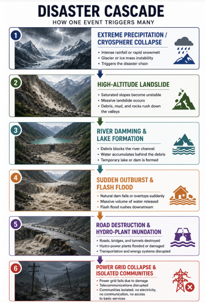
An ice avalanche triggers a landslide; the landslide blocks a mountain torrent; the temporary dam breaches, creating a debris flow; the debris flow destroys a highway bridge; the severed highway prevents emergency vehicles from reaching a collapsed hospital; the loss of the hydroelectric station trips the regional power grid.
ICIMOD’s strategic framework explicitly calls on regional governments to abandon single-hazard approaches in favor of multi-hazard risk governance. To operationalize this, Nepal should establish a National Mountain Hazard Observatory. This centralized facility would continuously synthesize data across the entire cryosphere, atmosphere, hydrosphere, and lithosphere. Rasuwa should serve as its foundational pilot project.
The Citizen Should Have One Recovery Identity
When a disaster strikes, victims frequently endure a second, administrative trauma. Displaced citizens are often forced to navigate a labyrinth of bureaucratic offices—proving their identity to one committee for emergency cash, demonstrating home destruction to another for temporary shelter, applying to a third for medical assistance, and petitioning a fourth for agricultural compensation.
This is a failure of state design. The burden of proof should never rest on a traumatized citizen; the burden of service rests on the state.
Nepal should introduce a unified Family Recovery ID for every household affected by major disasters. Linked to a centralized digital case management platform, this single digital ledger would track an affected family’s entire journey:
RescueShelter
One family. One digital record. One assigned municipal coordinator.
The state should actively monitor the family’s progress and automatically release entitlements as milestones are verified. Transforming disaster administration from a paper-chase into an integrated public service is the ultimate mark of a citizen-centric government.
Reconstruction Must Become Risk-Informed
As relief transitions to reconstruction, Nepal must resist the politically path-of-least-resistance option: rebuilding infrastructure and homes precisely where they were destroyed.
Certain settlements along river terraces can be protected through civil engineering; others will require bio-engineering and slope stabilization; some high-risk zones, however, must be declared permanently uninhabitable. Relocation decisions cannot be made on political whim or emotional sentiment alone. They must be governed by rigorous spatial planning that combines geology, hydrology, climate projections, land-use economics, and deep community consultation.
The guiding philosophy must be Build Back Better, as outlined in Priority 4 of the Sendai Framework:
- Rebuilt roads should not simply mirror old alignments; they should be engineered with enhanced drainage and bio-engineered slope stabilization.
- Bridges must be redesigned with higher clearances and deeper foundations capable of withstanding extreme discharge and heavy sediment loads.
- Public schools and government buildings should be engineered as dual-use facilities, serving as fortified evacuation shelters equipped with rainwater harvesting, solar micro-grids, and satellite communications.
- Settlement plans must map historical flood channels and geological fault lines before a single foundation is poured.
Rasuwa as a Transboundary Diplomatic Project
There is an unavoidable geopolitical reality that Nepal cannot ignore: mountain ecosystems do not conform to international boundaries.
The waters that inundated Rasuwa originated in the transboundary catchments near the border with China’s Tibet Autonomous Region. The Lhende Khola and Bhote Koshi rivers flow directly across the international border. A glacier collapse, a glacial lake outburst flood (GLOF), or a landslide dam breach in Tibet can devastate infrastructure and human lives in Nepal within hours—just as a disaster in Nepal can impact downstream communities and infrastructure stretching toward India.
Nepal must elevate disaster management from a localized civil protection task into a core pillar of climate diplomacy and human security.
With China and India, Nepal should establish automated, real-time hydrometeorological data-sharing protocols. High-altitude sensor data from upstream catchments in Tibet must flow directly into Nepal’s early warning centers via automated application programming interfaces (APIs), bypassing bureaucratic diplomatic channels when water levels breach safety thresholds.
With nations renowned for alpine engineering—such as Switzerland and Japan—Nepal should deepen technical partnerships focusing on high-altitude hazard mapping, avalanche control, tunnel engineering, and resilient mountain infrastructure.
Simultaneously, Nepal should leverage regional scientific platforms, particularly ICIMOD’s Hindu Kush Himalaya Disaster Risk Reduction Hub, to establish standardized research protocols and joint monitoring missions. At global climate summits (COP), Nepal should present the Rasuwa disaster not as an isolated local tragedy, but as empirical evidence of “Loss and Damage” caused by global climate inaction. Nepal must forcefully demand direct, grant-based climate finance from the global Loss and Damage Fund to build mountain resilience, rather than accumulating international debt to rebuild after climate-induced disasters.
A New Himalayan Compact
Rasuwa should serve as the catalyst for a broader regional initiative: a Himalayan Disaster Resilience Compact.
This compact would unite the nations sharing the Hindu Kush Himalaya around a shared human-security agenda:
- Open-access exchange of scientific data on cryosphere stability and hydrology.
- Joint satellite-based risk mapping and impact forecasting.
- Standardized cross-border early warning protocols.
- Joint training for specialized high-altitude search-and-rescue teams.
- Shared engineering standards for mountain infrastructure.
- Pre-arranged regional disaster response and climate financing mechanisms.
This would not be a geopolitical or military alliance. It would be a vital coalition for human survival among nations that share the same rivers, the same fragile geology, and the same escalating climate threats. Positioned at the geographical heart of the Himalaya, Nepal possesses the moral authority and diplomatic standing to lead this initiative.
The Real Test Begins After the Cameras Leave
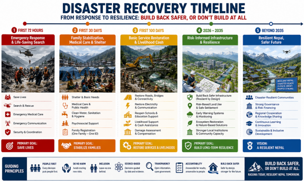
The most dangerous phase of any disaster is not the initial 72 hours of emergency response. It is the quiet months that follow—when emergency helicopters stand down, international news crews depart, public attention shifts, and displaced families remain in temporary shelters awaiting permanent housing.
To prevent institutional drift, Nepal must institute a clear, time-bound operational timetable:
Every stage of this recovery matrix must be monitored through an open, real-time public dashboard. Performance must not be measured by the total budget allocated or administrative meetings held, but by tangible indicators: How many families have transitioned into permanent, hazard-safe housing? How many schools have resumed classes? How many kilometers of vital supply routes have been permanently fortified?
Rasuwa as Nepal’s Turning Point: Build Back Safer, or Don’t Build at All
In the wake of every major tragedy, leaders routinely pledge that “this must never happen again.” In a dynamic, geologically active mountain range like the Himalaya, such promises are scientifically untenable. Human policy cannot stop the Indian tectonic plate from driving beneath the Eurasian plate, nor can it arrest every cloudburst or freeze-thaw cycle high in the mountains.
Natural hazards are inevitable. Catastrophic human vulnerability is not.
Nepal cannot stop the mountains from shaking or the ice from melting. But it can understand its terrain with scientific precision. It can monitor its glacial lakes and river basins with advanced technology. It can enforce strict land-use planning in river corridors. It can warn its citizens earlier, evacuate them faster, build infrastructure stronger, protect its most vulnerable households, and lead its neighbors toward regional climate cooperation.
That is the true meaning of resilience.
If Nepal turns one of its most painful disasters into the foundation of a modern, predictive, and scientifically grounded state apparatus—a strategy we might call Nepal Resilience 2035—then the legacy of Rasuwa will not be measured only by what was lost. It will be measured by the thousands of lives saved when the next mountain inevitably moves.
(Jitendra GC is a PhD scholar in Public Policy. He specializes in climate diplomacy, governance, and transboundary early warning systems in the HKH.)
Published on: २०८३ भदौ २८ गते १२:५१
No ads found for this position
Facebook Comment
Related News
latest Video
No ads found for this position
Trending News
- This Week
- This Month