BECA agreement: The US-India deal for geospatial cooperation
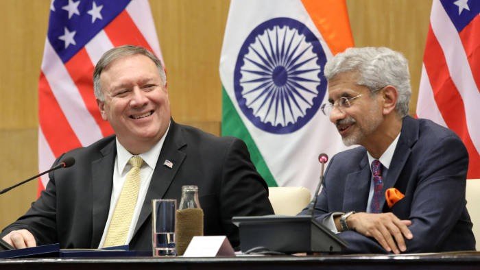
Kathmandu. The United States of America and India are both gearing up to participate alongside the rest of the members of the Quadrilateral Alliance (Quad) in the Malabar drills later this year. When Mike Pompeo, the US Secretary of State landed on India on the first leg of his Asia trip, for a 2+2 Ministerial dialogue, it was speculated that in the face of China’s increasing influence in the greater Indo-Pacific, the strategic ties would deepen between the two states. According to the Times of India, the nations are all set to sign the Basic Exchange and Cooperation Agreement for Geospatial Cooperation (BECA).
BECA is one of the four foundational agreements that the US signs with states that are considered to be its defense allies. Three of these core deals have already been signed by India and the US. The General Security Of Military Information Agreement (GSOMIA) was signed in 2002, that allows for an exchange of classified military information between the governments of the two states. The Industrial Security Annex later also paved the path for a better “industry-to-industry” cooperation. Another deal that provided for the refueling and replenishment facilities for the state militaries in each others’ territories, was the Logistics Exchange Memorandum of Agreement (LEMOA), signed in 2016. The Communications Compatibility and Security Agreement (COMCASA), was then signed in 2018 that gave India an access to the US’s encrypted systems.
BECA, is the last of these documents that was yet to be finalized between the India and the US. Once it is inked the countries will be able to share geospatial intelligent with each other in real time. According to the Economic Times, maps, aeronautical and nautical charts, commercial imagery, geodetic, geophysical, geomagnetic and gravity data can be shared between India and the US. It was previously halted by the United Progressive Alliance (UPA) government citing the concerns raised by the security forces, on sharing the classified and incredibly sensitive information with the other nation.
According to Captain Vikram Mahajan (Retd), Director of Aerospace and Defence at USISPF, “Data received under the agreement will be useful for long-range navigation and missile-targeting with enhanced accuracy. Given the current geo-political situation, this data will be relevant on both the northern and western borders of India. As this is a bilateral agreement, India will also be expected to share similar data with the US.”
Subrahmanyam Jaishankar, Minister for External Affairs and Mike Pompeo have agreed to sign the strategic document that will allow India to gain access to the highly accurate US satellite networks. With India locked in a stand-off against China in Eastern Ladakh, its continuous clashes with the Pakistani military within the Union Territory of Jammu and Kashmir (J&K), and its increasing engagement with the Quad states, the deal would amp up India’s strategic capabilities.
Facebook Comment
Related News


latest Video
Trending News
- This Week
- This Month